One WAY (WEST)

ONE WAY (WEST)
One Way signs are ubiquitous in cities, towns, and communities across the globe. Their shape, text, and color does vary, but everywhere they are used to indicate that the traffic flow must only travel in the indicated direction. If this instruction is ignored, a collision may ensue. This traffic sign and its role is an example of a one-way system used to prevent conflicting movement or dangerous points of contact.
One Way (WEST) aims to challenge the certainty of this commanding wayfinding icon. While many symbols, regulations, or policies, are put in place to structure and control the way materials and energy move through our world, inevitably, glitches occur. Seldomly, are the repercussions of these glitches isolated. Instead, they ripple out, entering other spaces, causing unforeseen consequences, and leaving behind visible (or invisible) effects.

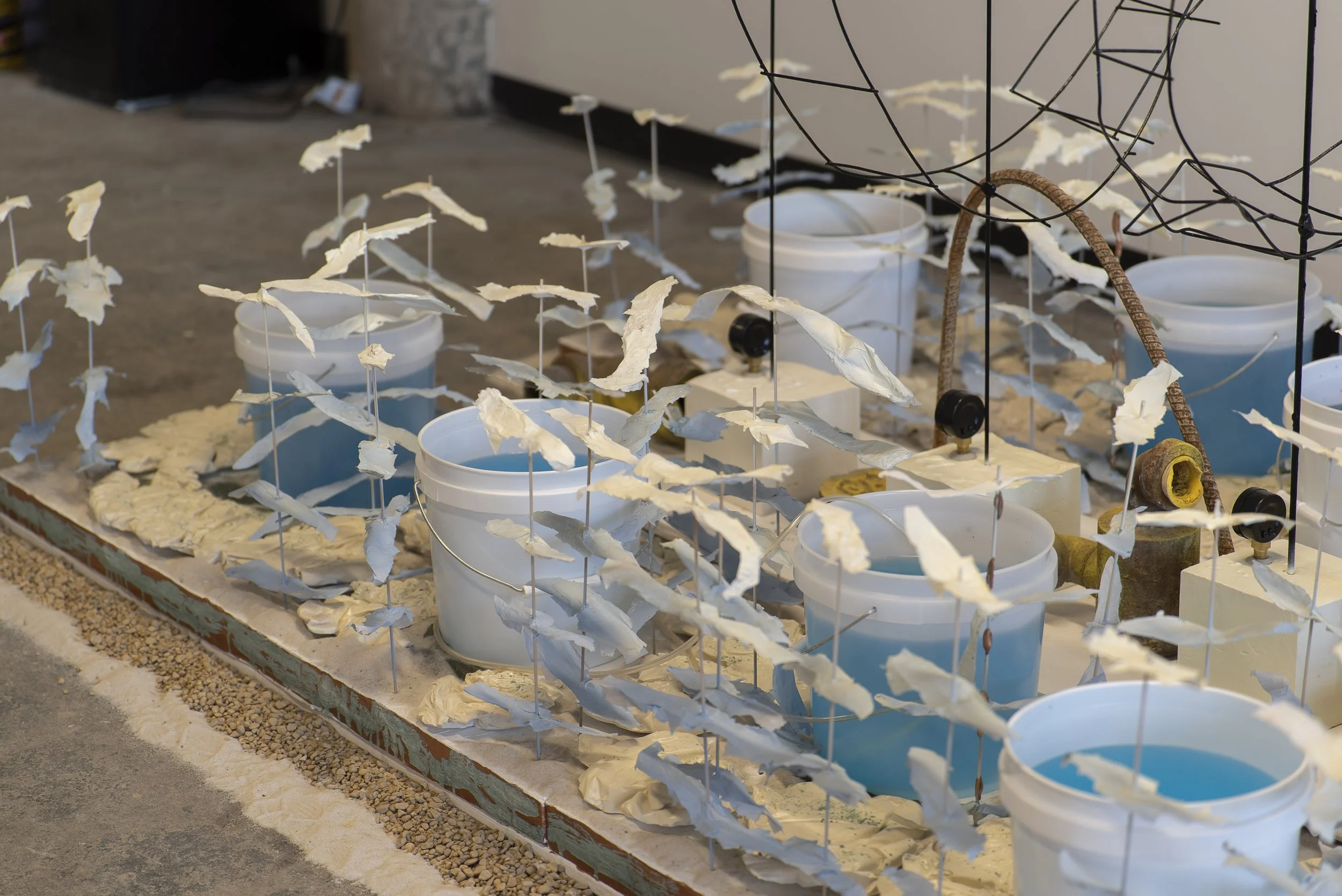
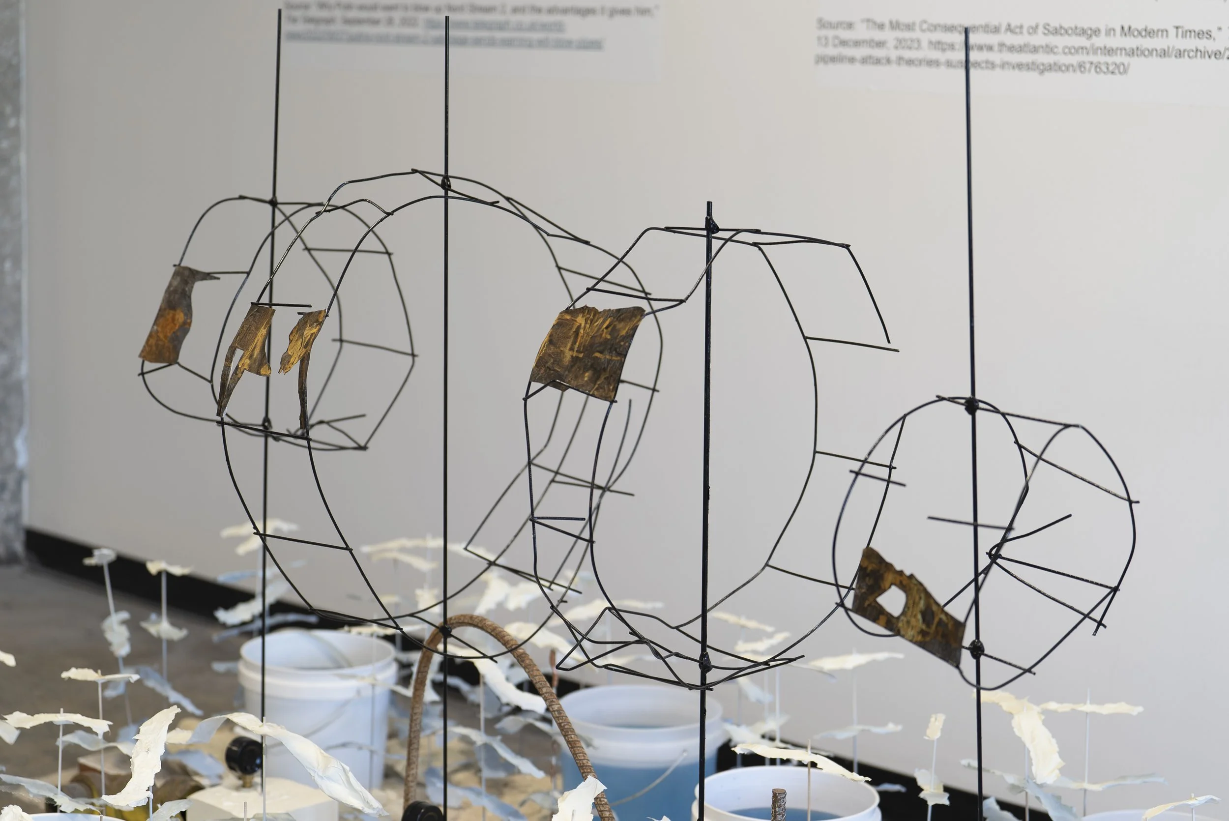
NS1 (A&B) and Ns2 (A)
On September 26th, 2022, there were a series of explosions and leaks in the Nord Stream pipelines (pipelines A & B of 1; pipeline A of 2) that run between Europe and Russia. As a result of the explosions, European oil prices increased, high levels of methane emissions were dispersed, marine life was negatively impacted, and seafloor sediment containing toxins was released into the Baltic Sea.
Investigations were launched into who planned and executed the attacks, but the story remains opaque even as media organizations continue to cover the shifting information. In addition to the economic and environmental impacts of the infrastructure attack, this sabotage further agitated political tensions between Russia, European and U.S. allies after Russia’s invasion of Ukraine in February that same year.

NS1 (A&B) and Ns2 (A)
Wood, plaster, wire, foam, paper, paint, acrylic, resin, vinyl, plastic buckets, air pressure gauges, dry pigments, sand, water, frozen water, air pump, and found pipes
56 inches x 108 inches x 64 inches (with three vinyl images each 30 x 40 inches)
NS1 (A&B) and Ns2 (A) Detail

NS1 (A&B) and Ns2 (A) Detail
NS1 (A&B) and Ns2 (A) Detail

NS1 (A&B) and Ns2 (A) Detail

NS1 (A&B) and Ns2 (A) Detail
Vinyl

NS1 (A&B) and Ns2 (A) Detail
Vinyl

NS1 (A&B) and Ns2 (A) Detail
Vinyl

NS1 (A&B) and Ns2 (A) Detail

NS1 (A&B) and Ns2 (A) Detail

NS1 (A&B) and Ns2 (A) Detail

Kinetic Energies
Oil on Canvas
54 x 84 inches

(L to R)
Dividing Up; PullinG Out
3Lines
Bending Around
(All) Oil on CaNvas’
(Each) 30 x 40 inches

(L to R)
Intersecting Lines
Rising Levels
Encircling
(All) Oil on CaNvas’
(Each) 30 x 40 inches

Heat Islands I & II
“Heat island effect” occurs when cities replace natural land with dense concentrations of pavement, buildings, and surfaces that retain heat. This effect increases the cost of air-conditioning, air pollution levels, and heat-related illnesses and deaths.
Heat lamp, cement, plaster, paint, metal foil, dry pigments, soil, and grass
29 inches x 13.5 inches x 14 inches (each)

Heat Islands I & II Detail

Heat Islands I & II Detail

Heat Islands I & II Detail

Constructing Cities
Ink and colored Pencil on Denril
24 x 36 inches (unframed)

Logistic Patterns
Ink on Denril
24 x 36 Inches (unframed)
